


GR-Les 4 Lacs

JMCMoreau
User
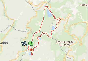

Length
16.9 km

Max alt
1303 m

Uphill gradient
769 m
Km-Effort
27 km

Min alt
952 m

Downhill gradient
769 m
Boucle
Yes
Creation date :
2019-08-26 17:03:57.931
Updated on :
2019-08-30 07:03:38.997
6h30
Difficulty : Difficult

FREE GPS app for hiking
 SityTrail
IGN / Geographical institutes
SityTrail Plus
The world is yours!
About
Trail Walking of 16.9 km to be discovered at Grand Est, Vosges, Le Valtin. This trail is proposed by JMCMoreau.
Positioning
Country:
France
Region :
Grand Est
Department/Province :
Vosges
Municipality :
Le Valtin
Location:
Unknown
Start:(Dec)
Start:(UTM)
355582 ; 5328436 (32U) N.
Comments